QUT has held a three-day drone workshop in Brisbane in a partnership with Landcare Australia and WIRES to train ‘citizen scientists’ from Queensland, NSW and Victoria to help identify and protect koalas, as well as kangaroos, wallabies, wombats and other wildlife.
Culminating in a final day of drone flying at SERF (QUT owned Samford Ecological Research Facility) in Camp Mountain on Thursday 13 April, Associate Professor Grant Hamilton from QUT’s School of Biology and Environment Sciences and Centre for the Environment is the architect behind this program which teaches participants about mission planning and scientific survey standards, and contains practical exercises including drone maintenance.
The exercise was the next step in the $1.5 million WildSeek Project which has established network of five Community Wildlife Intelligence Hubs, in the first steps to building a national AI network for the conservation and rescue response for native species.
The hubs are based in Noosa, Southeast Queensland, Tamworth, NSW, the mid-coast region of NSW, Greater Sydney, and East Gippsland, Victoria, with plans to further expand.
QUT is serving as the National Conservation AI Analytics hub, where infra-red drone footage collected around the country is being analysed using a QUT-created algorithm to identify koalas and other wildlife populations.
Community and Landcare group members and citizen scientist volunteers were being trained and licensed to use drones to capture data on local native animals.
Following licensing, QUT Drone Team experts from the Research Engineering Facility ran the three-day support and strategy workshop, organised by Associate Professor Hamilton, to provide guidance in data management and wildlife ethics training, as well as working through a range of on-ground scenarios.
Together local Community Hub staff, volunteers and partners are using the data analysed by QUT to make informed decisions regarding advocacy, protection and management of koalas, other wildlife and their habitat.
“The WildSeek Project’s initial focus is on identifying koalas, but it has the potential to expand to include multiple species including kangaroos, wallabies, birds and wombats, as well as identify invasive pests or other threats,” Professor Hamilton said.
“AI has been a very useful tool to find koalas and other species for a few years now, but threatened species in Australia are spread over vast areas, and this network of Community Hubs provides a more effective response in emergency situations by significantly improving knowledge of wildlife density and distribution across each region.
“Using drones gives us the greatest reach and the Noosa Hub has already started collecting data this way.”
Landcare Australia’s CEO Dr Shane Norrish described how right across Australia, Landcare and other community environmental groups are at the forefront of the protection and management of the local environment, and how WildSeek was supporting them.
“By equipping these Community Hubs with cutting-edge technology and support, WildSeek is helping them to understand, manage and better protect their local environments for the benefit of the community and the wildlife that live there,” Dr Norrish said.
WIRES CEO Leanne Taylor said recent bushfires, floods and other natural disasters highlighted the urgent need to monitor and manage wildlife over larger scales.
“With these coordinated Community Hubs and by using innovative technology, we will be able to generate and share accurate information on wildlife populations and individuals, enabling more effective response in emergency situations that will save countless lives,” Ms Taylor said.
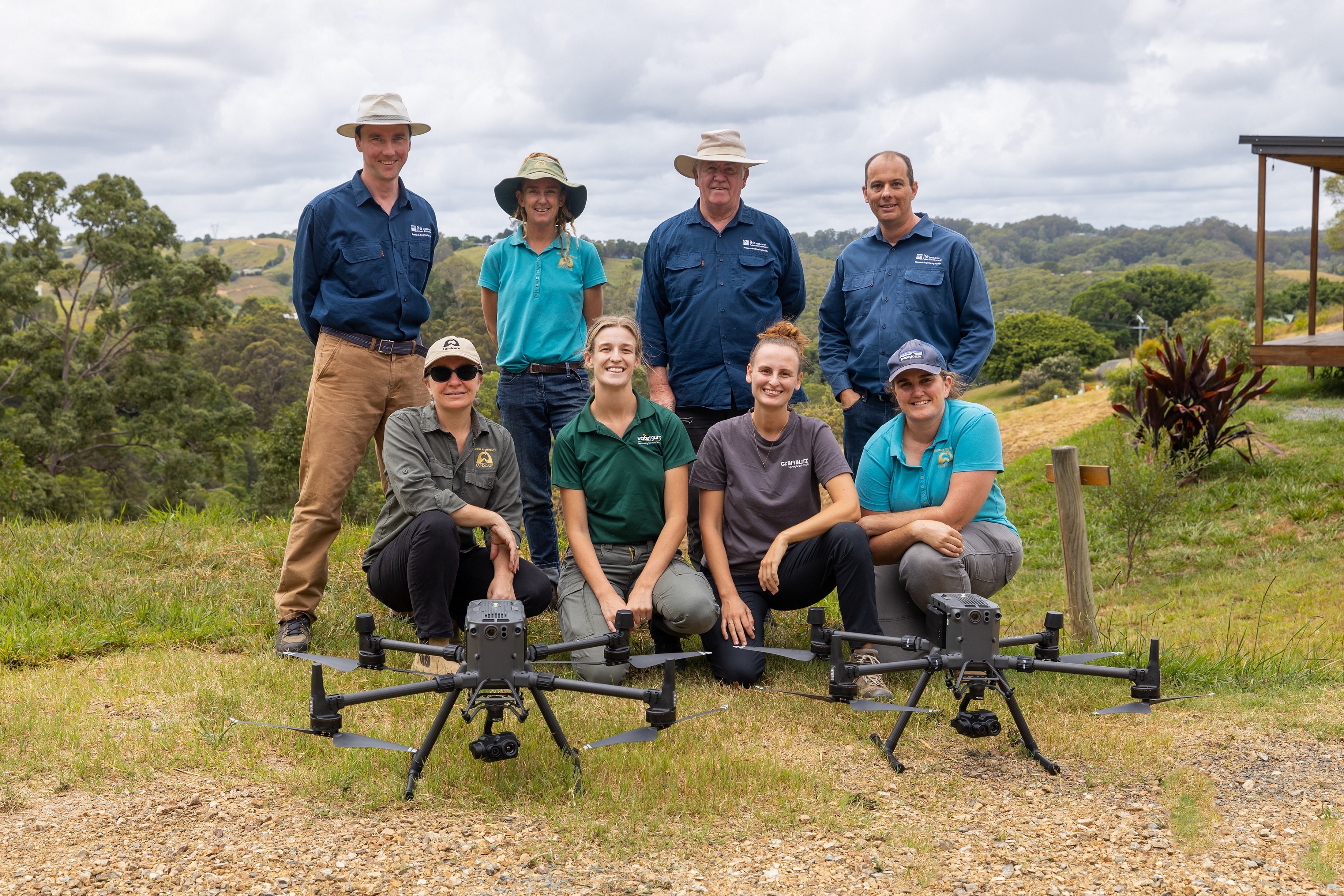
Main image: Noosa Landcare member Rachel Lyons with QUT drone trainers Dmitry Bratanov (left) and Gavin Broadbent (right) at QUT’s Samford Ecological Research Facility (SERF). Photo: Tony Phillips


