The NSW National Parks and Wildlife Service (NPWS) is planning a hazard reduction burn in Timmallallie National Park for Thursday 23 May, weather permitting.
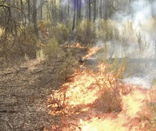
The hazard reduction burn is set to run for around 3 days and treat approximately 520 hectares of bushland east of Bugaldie.
Crews will be burning alongside Baradine Road, 2 km north of Bugaldie. Smoke hazard warning signs and speed reductions will be in place for surrounding areas. Roads closed in Timmallallie National Park include:
- Brolga Street
- Rocky Crossing Road
- Enright Road
- Patons Road.
The planned burns will help to improve protection for rural properties and nearby communities in the event of future bushfires. Planned low-intensity burns also aim to improve the park’s biodiversity and provide safer access for firefighters.
Neighbouring rural and residential properties in Bugaldie may be impacted by smoke, which is expected to be around for several days. Fire trails in the vicinity will be closed, however the hazard reduction burn will not impact visitor areas. Visitors must still check NPWS Alerts for up-to-date information.


