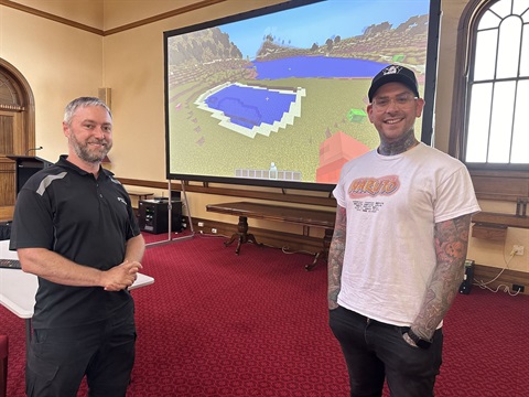
The City of Launceston has developed new maps — featuring a trio of the city’s most popular destinations — which can be uploaded into the popular video game Minecraft.
In 2021, the Council published a map of the city as a data visualisation tool for students, which could be imported into the Education version of the globally popular Minecraft video game.
The 2021 map was based on a 2016 LiDAR scan of central Launceston, but came with some limitations.
While the map was scale accurate, it was uniform grey in colour, and some anomalies captured in the scan were recreated as physical elements in the game.
City of Launceston Mayor Matthew Garwood said the Council had undertaken a new LiDAR scan of
Launceston in 2022 and it had made sense to update its Minecraft maps as a result.
“The Council typically uses LiDAR scans as part of its work in assessing planning applications across the city, but alongside this serious work there can also be some more fun applications elements,” Mayor Garwood said.
“We used some newer technology in our 2022 survey, which meant it was a simple process to create some new Minecraft maps based on the most recent data.
“We’ve created three maps, which feature Riverbend Park, City Park and the Cataract Gorge First Basin.
“The biggest difference with the new maps is that they represent the actual colours of features we see in Launceston.
“So for example, the big yellow Sky Walk in Riverbend Park is a big yellow Sky Walk in the newest Minecraft map, the green grass in City Park is green in the Minecraft map, and the stone barbecue shelters
at the First Basin are stone coloured in the game.
“But make sure that when you’re playing the game, you don’t get distracted by the colours and familiar spaces — because there are zombies about.”
City of Launceston Smart Cities Project Officer Cameron Smith said the Council had tested the maps out with students at National Science Week at the Queen Victoria Museum and Art Gallery in August.
“We had approximately 800 students come through during National Science Week, and we had the maps running on four PCs and three iPads,” Mr Smith said.
“Students were encouraged to show us their favourite parts of parks and to show us their big ideas by building them in the game.
“We know a number of schools across Tasmania have downloaded these maps and have used them in the classroom, including St Thomas More’s Catholic School . St Thomas More’s have identified Minecraft
Education as an effective teaching tool, building creative problem-solving skills and systems thinking.
“These maps are a good example of how Launceston’s data can be visualised in different and exciting ways.
“Children are often difficult to engage when it comes to local government, but they respond well to games and visualisation tools that allow them to consider their world from a new perspective.
“We know there are children who are using these maps at the moment and others who will download them as a result of hearing about them.
“We’d love to see the ways in which people are using the maps. We’ve established a dedicated email address, [email protected] — so if you make something exciting with one of our maps we’d love to see it.”
The new Minecraft maps, along with instructions for installation, can be downloaded here.


