The El Niño-Southern Oscillation (ENSO) is now in an El Niño phase. El Niño events are part of a natural cycle in the Pacific Ocean that can affect global weather.
What El Niño usually means for Australia’s climate
El Niño often brings drier conditions to central and eastern Australia in winter and spring. But Australia’s weather is also shaped by other climate factors, so outcomes can vary.
For the most reliable outlook for the coming months, follow our long-range forecasts. We update them regularly and they reflect the latest conditions.
Recent El Niño (2023-24)
The last El Niño was a moderate to strong event that developed in spring 2023 and lasted into early 2024.
August to October 2023 was Australia’s driest 3-month period on record. A strong positive Indian Ocean Dipole (IOD) also contributed to the dry conditions.
El Niño had less influence from late 2023. Storms along the east coast and 4 tropical cyclones brought above average rainfall to widespread areas during the summer months.
Outlook for winter and spring 2026
Our long-range forecasts are most reliable up to 3 months ahead. For July to September the forecast issued on 11 June showed:
- rainfall is likely to be below average across parts of southern and eastern Australia
- temperatures are likely to be above average in most areas, except parts of the north.
Below average rainfall does not mean no rain – just less than usual.
These forecasts cannot predict specific events in advance. For example, an east coast low can bring heavy rain in winter.
How El Niño affects the forecast
When we report El Niño is underway, our rainfall forecasts don’t suddenly shift. Our forecasts take into account all the different influences from our oceans and atmosphere to assess the likely rainfall and temperature patterns in the coming months.
During El Niño, the Pacific is likely to be extending a dry influence on our rainfall patterns. However, other factors can either boost or reduce this effect.
Our long-range forecast responds to all the variations in our climate systems including:
- warmer than average regional sea surface temperatures
- the long-term drying trend in southern Australia.
We have been reporting signs of El Niño developing since March.
Typical impacts
Past El Niño events have often coincided with:
- less rainfall in winter and spring, particularly in the eastern half of Australia
- higher daytime temperatures in southern areas
- increased frost risk due to clearer skies.
However, in a warming climate, past patterns are less reliable as a predictor of future impacts.
Every El Niño is different
No 2 events are the same. Rainfall and temperature impacts can vary from one El Niño event to another. For example, winter to spring rainfall in 2002 was very different from 2015.
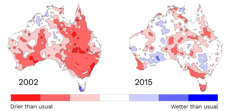

Winter to spring rainfall deciles in Australia during El Niño events in 2002 compared to 2015
Winter snow season
El Niño years tend to have lower peak snow depths in Australia’s alpine region.
But this does not necessarily result in a poor snow season as snowfall can vary greatly over the course of a season. Reduced rainfall and cooler night-time temperatures can help retain snowfall on the ground.
Why impacts vary
ENSO is only one part of the climate system. Other influences include:
The IOD is currently neutral, but models suggest a positive IOD may develop during winter. If this happens alongside El Niño, it can increase the chance of drier conditions, especially in southern and eastern Australia.
How strong is this El Niño?
The expected strength of an event is based on forecasts of sea surface temperatures in the tropical Pacific. Most models suggest this event is likely to be strong to very strong.
We assess ENSO event strength using:
- observed ocean temperatures
- the Southern Oscillation Index (SOI) – which measures changes in the overlying atmospheric circulation patterns.
The strength of the event doesn’t always match the strength of its impact in Australia. A weaker event can have major effects, while a stronger one may not.
How long will it last?
El Niño events usually last 6 to 12 months, though in some rare cases, El Niño has persisted for up to 2 years.
Current forecasts show El Niño conditions are likely to persist well into the latter half of 2026. El Niño events typically peak in summer, before weakening in the first quarter of the calendar year. The influence on Australia’s rainfall patterns typically reduces around early summer.
What about summer?
It’s too early to say what summer will be like. The outlook will become clearer by late spring.
El Niño can increase the risk of extreme temperature shifts, like heatwaves and hotter days. A warming climate increases the likelihood of:
- hotter conditions
- heatwaves, including marine heatwaves
- fire weather
- heavy rainfall and flooding events.
Will this year be extra hot?
Most of the southern half of Australia has had above average temperatures so far this year. But it’s too soon to know how 2026 will play out.
The additional heat in the tropical Pacific that emerges during El Niño events typically boosts global temperatures in the following year.
The long-term warming trend has significantly increased the likelihood of warmer than average years. Australia has had 14 of its 15 warmest years on record since the year 2000.
Does El Niño increase drought risk?
El Niño can contribute to dry conditions, but it is only one factor.
Since January 2026, it has been drier than average in:
- north-eastern New South Wales into southern Queensland
- southern Victoria
- western and northern Tasmania
- parts of Western Australia including the south-western corner.
We publish a monthly Drought Statement to track areas with serious or severe rainfall deficiencies.
What it means for you
You can check likely rainfall and temperatures for your area using our long-range forecast.
Select your location to explore the latest details.


