The NSW National Parks and Wildlife Service (NPWS) is planning an 850-hectare hazard reduction burn in the Glenbrook area of Blue Mountains National Park from tomorrow (26 March), weather permitting.
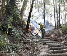
The planned burn will be carried out over consecutive days this week, beginning Tuesday 26 March. The aim is to reduce naturally accumulated fuel loads in the park, helping to provide strategic protection for the residential areas of Glenbrook, Lapstone and Mulgoa, in case of future wildfire.
The Glenbrook precinct of Blue Mountains National Park will be closed during the burn operation. The closure extends to popular walking tracks and visitor areas including:
- Euroka campground
- Red Hands Cave
- Red Hands Cave walking track
- Glenbrook Gorge track
- Blue Pool walking track
- Jack Evans walking track
- Jellybean track
- Nepean lookout
- Nepean River walking track
- Portal lookout
- Tunnel View lookout
- Woodford Oaks trail
Visitors must check NPWS Alerts for up-to-date information on track, trail and park closures, noting areas will be re-opened when deemed safe by fire crews.
Smoke may be visible along the Great Western Highway and the M4 for the duration of the burn. Motorists in the area advised to use caution and drive to conditions.
People vulnerable to smoke are encouraged to remain indoors and keep their doors and windows closed to reduce exposure.
This burn is one of many hazard reduction operations undertaken by NPWS each year, many with assistance from the Rural Fire Service and Fire and Rescue NSW.


