DR.SAT can help you measure your business’s drought resilience across environmental, financial and personal areas; then discover practical options to increase your resilience, step-by-step. PHOTO: Jason Edwards
Are you looking for ways to make your farm business less vulnerable to drought and changing climate? DR.SAT is a new self-assessment tool for farmers to understand their own farm-scale resilience, see farm-level climate change projections and view satellite data for their farm. It is free to use and offers options tailored to your circumstances.
![]()
Assess your farm’s resilience with DR.SAT
- Simple surveys to assess resilience
- Satellite images (roughly) every 6 days
- Climate projections for your farm
- Options and links to resources
Farming communities have been dealing with drought, floods, fires and other changes in the climate for a long time. But with droughts and extreme weather predicted to become more frequent across much of Australia, it is clear farmers need forward thinking to keep their farms, land and communities thriving.
There are lots of things farmers can do to ensure they are prepared for drought. There are many examples of farmers who have been able to stay more productive, and recover faster, following drought because of the way they manage their land and natural resources. On the environmental front, managing groundcover, water flow, soil carbon and moisture, and switching to alternative fodder and crops, as well as various grazing and cropping strategies are some of the options.
But the first step is making sure you’ve got the right information so you can make the right decisions. DR.SAT (which stands for Drought Resilience Self-Assessment Tool) is a free online tool now available to support farmers in better decision-making.
DR.SAT is funded through the Australian Government’s Future Drought Fund. It’s the first of its kind, combining satellite data at a farm-level, with trustworthy farm-level climate projections, and the ability for farmers to ‘sense check’ their level of resilience and get tailored options that can help them better prepare for future drought and climate risks.
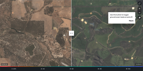
Using DR.SAT to assess groundcover on a property on two different dates – which can help you assess how your land is changing over time.
By logging on at www.drsat.com.au, you’ll be able to explore this free tool and have:
- the ability to input details about your farm and see satellite images of historic and current condition, including ground vegetation, surface moisture and land surface temperature specific to your farm (updated roughly every six days).
- climate projections for your property and region for 2030 and 2050.
- simple questions about your land condition, financial, physical and mental wellbeing to assess your resilience, including options for the future with links to resources to support in building your resilience.
DR.SAT was developed with farmers, for farmers and it taps into expert advice from industry bodies, farm business advisors and others. It uses climate data from Climate Services for Agriculture (CSA) a joint initiative of the Bureau of Meteorology and the CSIRO.
“The bird’s eye view stuff – now that’s a really neat tool.”
Livestock and grains farmer, Northern NSW
Since the first release of DR.SAT in December 2021, the tool has evolved from a focus on cattle grazing and dry land cropping to now include commodities such as sheep, wool, dairy, citrus and temperate fruits.
DR.SAT can be used by all Australian farmers, but provides deeper insights in specific regions and commodities. For sheep producers (both meat and wool) in Condamine and the Northern Tablelands of NSW, the Victorian Mallee and the WA Sheep Wheatbelt for sheep, you can get specific insights to build your environmental resilience. This will expand to national coverage at the end of 2022.


