It’s already been a really wet week, particularly across south-east Queensland.
We’ve already seen plenty of flash flooding and more is possible over the next few days.
Storms are on the forecast for Brisbane and Canberra, as well as possibly Sydney and Melbourne over the course of the weekend, and in the capitals and elsewhere right across eastern Australia.
Severe thunderstorms could bring down trees and power lines, bring heavy rain, more flash flooding, and large hail is a risk as well in some areas. Localised power outages are possible.
So, the rainfall that’s to come over the next three days or so, many areas in the orange and pink here are expecting 20 to 50 mm of rain, mainly with thunderstorms, and much more than that in some areas, particularly through these areas of central Queensland.
Some spots will see well over 100 mm over the next few days, and that comes on the back of what’s already been a really wet week across many areas of Queensland.
100 to 300 mm in the gauges over the last seven days through south-east Queensland and north-east New South Wales, totals as high as 450 mm over seven days on the Sunshine Coast Hinterland, and many other areas that have seen 50 to 150 mm of rain across the last week.
So, what does it look like on the weather map over the next few days?
Well, plenty of wet weather through much of Queensland on Saturday, extending into northern New South Wales as well.
Meanwhile, in the south, this cold front and trough will pick up a lot of that tropical moisture and bring rain to South Australia, Victoria and Tasmania, particularly late Saturday and into early Sunday.
Severe thunderstorms also possible across some of these areas, as we’ll see in a minute. And then on Sunday, we’ll see that system track east across New South Wales.
So, plenty of rain during the night for Victoria and Tasmania.
And then a major severe thunderstorm outbreak on Sunday afternoon, extending from eastern Victoria through western New South Wales and right up through western Queensland as well.
And then on Monday, the last major day of this system, we’ll see the focus move to north-east New South Wales and southern Queensland before the system finally moves offshore later Monday, and things settle down a bit more into next week. So, here’s the thunderstorm map for Saturday afternoon.
We can see two yellow areas where severe thunderstorms are possible.
A very large area through Queensland where heavy rain is the main risk, with severe thunderstorms right up from Townsville down to the Sunshine Coast Hinterland and out to western Queensland as well.
And through South Australia, we’ve already seen a warning this morning near Ceduna.
Through South Australia and parts of Victoria, severe thunderstorms are possible through the afternoon, including perhaps through the outer eastern suburbs of Melbourne.
That’s the most likely part of Melbourne to see severe thunderstorms on Saturday afternoon. Now, looking ahead to Sunday, and we can see a very colourful map here.
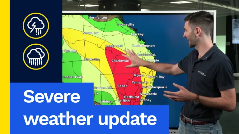
A large red area where severe thunderstorms are likely on Sunday afternoon.
I mentioned a major severe thunderstorm outbreak expected on Sunday afternoon through the evening, right from eastern Victoria through Canberra and the ACT, Orange, Bathurst, Tamworth, right up through western Queensland there as well, and then extending through to the coast later, including Brisbane, where heavy rainfall is the main risk through south-east Queensland and north-east New South Wales.
And through Sydney, later in the evening, Sydney could see a severe storm in the evening on Sunday, bringing potentially damaging winds and maybe some heavy rain as well.
Further inland, there’s the risk of all three of those major hazards: heavy rain, large hail and damaging winds, and particularly through this area down here, through the Riverina, around Albury-Wodonga and into north-east Victoria as well.
Destructive wind gusts are possible in perhaps one or two stronger supercell severe storms that could develop in that area on Sunday afternoon.
And then on Monday, as I said, the focus moves to north-east New South Wales from about Coffs Harbour, north through the Northern Rivers and up towards south-east Queensland, including Brisbane, Ipswich and the Gold Coast as well on Monday afternoon.
So, this is your more classic springtime severe thunderstorm outbreak for this part of the world, unlike what we’ve seen in the last week, which is really a summertime pattern of days and days of this heavy rain and tropical moisture.
So, this will be the last day of this thunderstorm outbreak, and it should pack a punch too on Monday afternoon, with the potential for more severe storms there through that part of the country.
So, there’s plenty of severe weather on the forecast over the next few days.
Please take care if you’re out and about in eastern Australia, particularly in Queensland, where flash flooding, as I’ve said, is an ongoing risk.
We’ve already seen people driving into flooded roads and creeks and having to be rescued. We don’t want to see any more of that.
Keep up to date with the latest warnings and check your radar in your local area as well.
You can find all that and more on our website, on our app, and find our social media channels for more as well. Thanks for watching! Stay safe.
Video current: 12:00 pm AEDT Saturday 24/10/26.