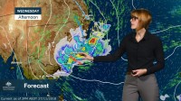
METEOROLOGIST GRACE LEGGE: Hello from the Bureau. A wet and windy day is expected for parts of eastern New South Wales tomorrow, with a low pressure system deepening off the coast.
The low is currently moving over New South Wales and unfortunately only bringing light rainfall over western parts.
The low moves off the coast early Wednesday, deepening as it interacts with the ocean. As the system strengthens, we’ll see significant rainfall wrap around and affect coastal areas. Heavy rainfall of 50–100mm is forecast, with isolated falls above 200mm possible in some areas. The Sydney metro and Illawarra regions are most likely to see the heaviest falls, which may cause flash flooding, but other districts around them may also be affected. The location of the heaviest rainfall is highly dependent on the convergent bands around the low and where individual thunderstorms form.
Due to this significant rainfall, a Flood Watch is current for coastal rivers between the Central Coast and St Georges Basin, where localised minor to moderate riverine flooding may develop from Wednesday.
Rainfall is expected to start easing from late Wednesday, but is not the only hazard associated with this system. Damaging wind gusts in excess of 90 km/h and hazardous surf conditions are also forecast along the coastal fringe for Wednesday morning, and may extend further along it by the evening. Winds will ease later on Thursday as we start to see this low move away from the coast, taking much of the weather with it.
With all this severe weather on its way, please follow advice from your local emergency services and keep up to date with the latest warnings and forecasts on the Bureau’s website and app.


