So it’s going to be an active week across much of south-eastern Australia this week, and I’ll show you what’s driving all of that.
But firstly, the main story will be rainfall this week as multiple waves of cold fronts and troughs sweep across south-eastern Australia. They’re going to have ample access to moisture coming down from the Indian Ocean, but also from the Coral Sea in the low levels, and that’s going to provide enough moisture to bring widespread rainfall as these weather systems move through.
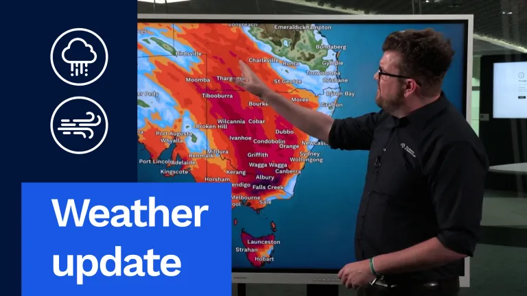
As you can see, we’re looking at widespread at least 10 to 30 mm for much of Victoria, southern South Australia, Tasmania, pretty much all of inland New South Wales and even into south-west Queensland as well. But where we’re going to see the heaviest falls will definitely be focused around north-west New South Wales from Tibooburra through Wilcannia, Cobar, Ivanhoe, down through Griffith, Wagga Wagga and into north-eastern Victoria, where these areas could see 50 to 100 mm, and far north-eastern Victoria, particularly around our alpine areas, could see up to 150 mm or more, and that’s going to cause some flooding impacts. And I’ll show you that shortly.
But notice little if any rainfall reaching our populated east coast. This really is an inland and farming weather event with lots of rain on the way.
So where do we stand right now?
The first weather system is moving through parts of South Australia and New South Wales. Here’s a cold front moving through South Australia. And notice these showers coming down from the north through inland New South Wales. That’s our low-level moisture I talked about.
Now all this is going to combine tonight and through Tuesday to produce a band of rain to sweep across inland south-eastern Australia. And we can clearly see that, particularly by the time we get through Monday night into the early hours of Tuesday morning. We could see a band of rain and storms pretty much from western Queensland all the way down through New South Wales and into north-eastern Victoria, with widespread showers and patchy rain behind that through South Australia and western Victoria.
And then that merges as we move through Tuesday morning and Tuesday afternoon into a band of rain and thunderstorms through inland New South Wales and much of central and eastern Victoria as well, with heavy falls around north-eastern Victoria, with showers and rain also impacting parts of northern Tasmania. And that will continue to move through on Tuesday afternoon and Tuesday evening.
But then we look west and our next weather system starts moving into South Australia by the time we get into Tuesday night.
Then we move through Wednesday, and that’s going to be a big day. We’re going to see thunderstorms and heavy falls develop, particularly through eastern South Australia as we get through Wednesday morning. That’s going to move eastwards into New South Wales and northern Victoria with rain, severe thunderstorms with large hail and damaging winds. And then it’s going to congeal into a big band of rain again from south-west Queensland all the way down through New South Wales and much of Victoria, eastern South Australia and eventually into Tasmania as well.
And notice these darker colours through parts of New South Wales and north-east Victoria. That shows us where we’re likely to see some heavy falls as we move into Wednesday afternoon and Wednesday night.
And then you can see Thursday’s system starting to reload up in the Bight of Australia, rain also impacting parts of Tasmania.
But storms, as I mentioned, are the main focus of this event, and these are likely to see severe thunderstorms across these yellow areas. But the area of most concern for our highest-intensity thunderstorms around that Broken Hill, Mildura area and eastwards from there as well. These storms could produce large hail, damaging winds and heavy rainfall. A little unusual for July, but all the dynamics and ingredients are coming together. So something to watch closely, particularly if you live in these yellow- or red-highlighted areas.
Then we move into Thursday and we’re going to see that next weather system move into South Australia and then through much of Victoria and southern New South Wales. This has got a lot of wind with this system, but also much colder air. So we’ll finally start to see some snowfall for our alpine resorts of Victoria and New South Wales. Some welcome news there.
But before that there’s going to be a lot of rainfall. Now you saw all that rainfall earlier. That means we’re going to see Flood Watches and Warnings issued in the coming days. We already have Flood Watches current for a number of rivers in Victoria, including the Upper Murray, Mitta Mitta, the Kiewa River, Broken River, Seven and Castle Creeks, as well as parts of the Goulburn.
So that means if you live in these highlighted areas, forecast rainfall in the coming days is likely to lead to flash and riverine flooding, with isolated to even moderate to major flooding possible depending on where those heaviest falls occur.
So it is important if you live particularly in north-eastern Victoria in the coming days to stay up to date with the latest forecasts and warnings via our website and app.
Now just some of the impacts of this heavy rainfall. Obviously heavy rainfall over widespread areas, particularly our agricultural areas of New South Wales and Victoria. So welcome news for some, but maybe too much of a good thing for others. But particularly in north-eastern Victoria, we could have too much rainfall that will lead to flooding.
Those strong winds will start coming into south-eastern Australia on Wednesday and Thursday, with damaging winds possible for elevated areas of Victoria and coastal parts of South Australia and Victoria.
And as I mentioned earlier, good news for those looking for snow. We look like we’ll see that snow developing for our alpine areas on Thursday and into Friday morning.
So with all this weather forecast around much of south-eastern Australia in the coming days, remember to stay up to date with the latest forecasts and warnings via our website, app and social media. And once that weather really picks up mid to late week and Flood Warnings may be issued, make sure you also listen to your local emergency services, and we’ll continue to keep you updated here at the Bureau.
Video current: 1:00 pm AEST Monday 29/06/26.


