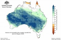
The Bureau of Meteorology will today release its 2020 Winter Outlook, with most of the country showing an increased likelihood of wetter than average conditions in the coming three months.
The Bureau’s Manager of Long-range Forecasts, Dr Andrew Watkins, said there were only a few areas across the country that weren’t looking at a wetter than average winter.
“Most areas of mainland Australia are showing a better than 70 per cent chance of having a wetter than average winter,” Dr Watkins said.
“The only exceptions are the coastal fringes of NSW and eastern Victoria, parts of Tasmania and areas of southwest WA where the outlook isn’t pushing towards wetter or drier than average conditions.”
“Parts of northern Australia are also showing no strong push towards wetter than average conditions, but this is typically the dry season anyway.”
Dr Watkins said the outlook was being largely driven by warmer than average ocean temperatures off north west WA, as well as warm ocean temperatures in the western Pacific.
“Ocean temperatures in the eastern Indian Ocean are currently warmer than normal, and our models are predicting they will warm further throughout the winter months.
“When warm sea surface temperatures occur closer to Australia, weather patterns shift towards us too, favouring more cloud and rainfall across the country.
“We last saw this happen in 2016, when a strong negative Indian Ocean Dipole formed to the west of Australia. This was the last time we saw tropical moisture from the northern Indian Ocean deliver good winter rainfall to large parts of Australia.
“We aren’t guaranteed the same results as 2016, but the warmer ocean temperatures surrounding the continent will push us in the direction of better than average rainfall.
“As always, it’s important people use the outlooks in conjunction with all of the Bureau’s other tools to make decisions, including the seven-day forecast which will provide details on potential rainfall for the immediate days ahead.”
Daytime temperatures throughout the winter months are expected to be cooler than average for much of the southern half of the country, but warmer than average along the eastern seaboard and most of northern Australia.
Overnight temperatures are likely to be warmer than average across the entire country.
“When we look at the expected temperatures, they really fall in line with the expected rainfall conditions.
“Areas with a higher chance of above average rainfall are also looking at increased chances of cooler than average days because they are more likely to have cloud cover and more evaporative cooling in the coming months.
“Conversely, it means our nights are more likely to be warmer than average, because that cloud cover will prevent heat from escaping during the evenings.”
On Monday 1 June, the Bureau will release its state and national autumn summaries.
Preliminary data shows much of northern and western Australia had a warmer than average autumn, but the season has been interspersed with periods of very cold weather.
Most of south eastern Australia has had a cooler than average autumn period.
Autumn rainfall is likely to have been above average through most of the south east, and parts of central Australia and northern WA.
Conditions have been drier than average through most of southeast Queensland and parts of northeast NSW. Large parts of WA were drier than average for autumn but recent and expected rainfall in the coming days could push some areas of WA closer to average rainfall for the period.


