Just like honey slowly dripping from a spoon, parts of the rocky outermost layer of Earth’s shell are continuously sinking into the more fluid layer of the planet’s mantle over the course of millions of years. Known as lithospheric dripping – named for the fragmenting of rocky material that makes up Earth’s crust and upper mantle – the process results in significant deformations at the surface such as basins, folding of the crust and irregular elevations.
Though the process is a relatively new concept in the decades-old field of plate tectonics, several examples of lithospheric drip around the world have been identified – the Central Anatolian Plateau in Turkey and the Great Basin in the western U.S., for two. Now, a team of researchers led by Earth scientists at the University of Toronto has confirmed that several regions in the central Andes Mountains in South America were formed the same way.
And they’ve done so using materials available at any hardware store and art supplies outlet.
“We have confirmed that a deformation on the surface of an area of the Andes Mountains has a large portion of the lithosphere below avalanched away,” says Julia Andersen, a PhD candidate in the department of Earth sciences at U of T and lead author of a study published in Communications Earth & Environment, part of the Nature family of journals. “Owing to its high density, it dripped like cold syrup or honey deeper into the planetary interior and is likely responsible for two major tectonic events in the Central Andes – shifting the surface topography of the region by hundreds of kilometres and both crunching and stretching the surface crust itself.
“Overall, the results help define a new class of plate tectonics and may have implications for other terrestrial planets that do not have Earth-like plate tectonics such as Mars and Venus.”
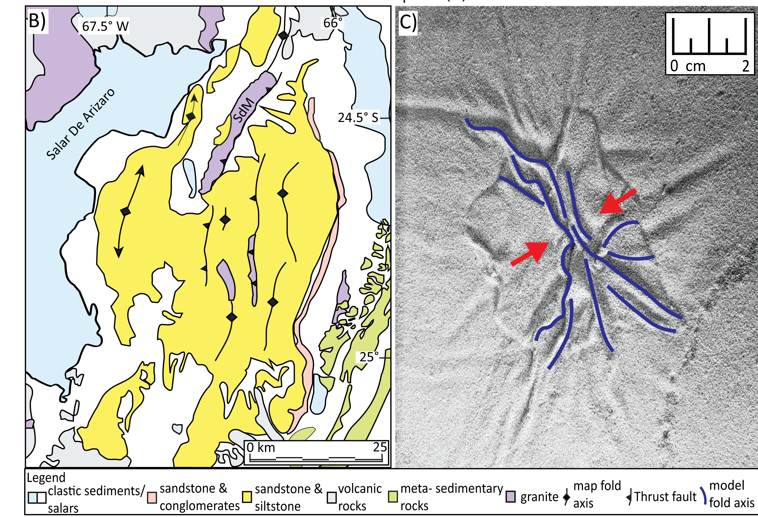
A geological map of the Arizaro Basin, demonstrating folding and thrust faults within the basin, as compared with surface view of the experimental simulation of lithospheric dripping. Folding and direction of shortening is depicted with red arrows. Photo credit: Left: DeCelles, et al. (2015). Right: Julia Andersen et al. (2022).
Lithospheric dripping occurs when portions of the lowest layer of Earth’s outer shell thicken and begin to drip into the mantle below when warmed to a certain temperature.
As the fragments sink into the lower mantle, it first forms a basin at the surface which later springs up when the weight below breaks off and sinks further into the deeper depths of the mantle. This results in an upward bobbing of the land mass across hundreds of kilometres.
The Central Andean Plateau is defined by the Puna and Altiplano high plateaus and was first formed when the Nazca plate slid beneath the South American plate during the well-documented plate tectonics process of subduction, during which a portion of the heavier of two tectonic plates sinks into the mantle when they converge.
Past studies have suggested, however, that the subsequent rise of Central Andean topography has not been uniform in time but rather was built through sporadic pulses of uplift throughout the Cenozoic Era that began approximately 66 million years ago.
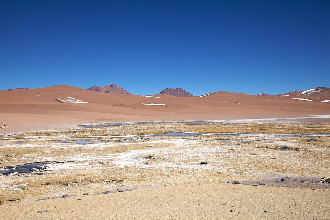
Geological estimates indicate that the relative timing and mechanism of uplift in the region and the styles of tectonic deformation are different between the Puna and Altiplano plateaus. The Puna Plateau is characterized by higher average elevation and includes several isolated inland basins, such as the Arizaro Basin and the Atacama Basin, and distinct volcanic centres.
“Various studies invoke removal of the lithosphere to account for the widespread, non-subduction related surface deformation and evolution of the plateaus,” says Earth sciences Professor Russell Pysklywec, co-author of the study and Andersen’s PhD supervisor. “Further, crustal shortening in the Arizaro Basin interior is well documented by folding and local thrust faults but the basin is not bounded by known tectonic plate boundaries, indicating there is a more localized geodynamic process occurring.”
Geoscientists have used the sedimentary rock record to track changes in surface elevation of the Central Andes since the Miocene epoch approximately 18 million years ago. Seismic imaging provides a remote image of Earth’s interior much like an ultrasound for a human body, illuminating a new view of the lithospheric drip structures.
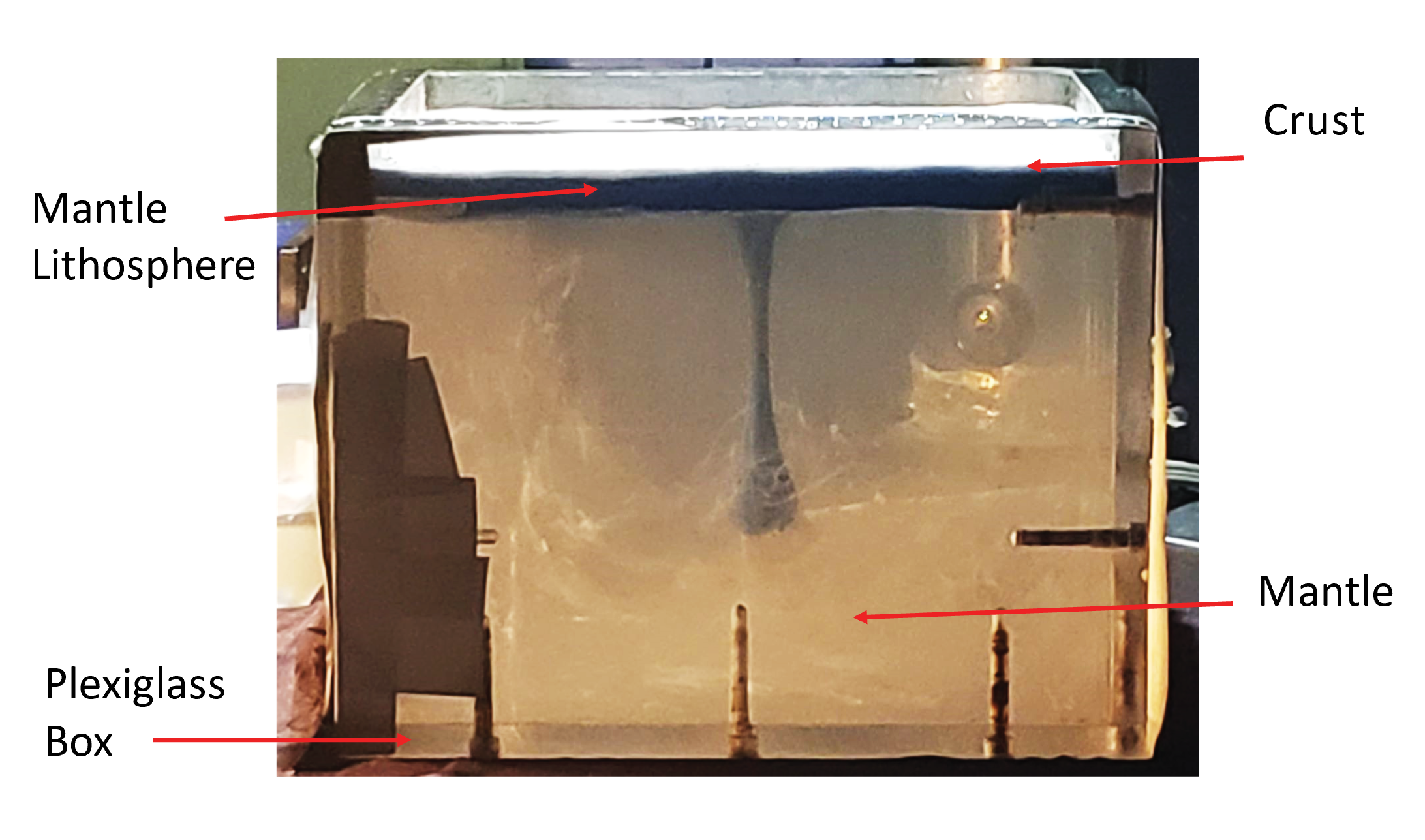
A simulation of the rocky outermost layer of Earth’s shell using silicone polymer fluid, modelling clay, and a sand-like layer made from ceramic and silica spheres demonstrates the process of lithospheric dripping. (photo by Julia Andersen/Tectonophysics Lab/University of Toronto)
Andersen and her colleagues say past geological studies advance evidence for lithospheric drips in the region, but the dynamical processes of lithospheric dripping and their role in driving local surface tectonics in these purported geological cases are uncertain. For the most part, geodynamic model predictions have not been tested in the context of direct regional geological or geophysical observations.
So, the team set about developing analogue laboratory models with geological and geophysical constraints to recreate what happened over thousands of centuries and test their hypothesis that the topographic and tectonic evolution of hinterland basins of the Central Andes was caused by lithospheric drip processes.
“Recognizing the massive time and length scales involved in these processes – millions of years and hundreds of kilometres – we devised innovative three-dimensional laboratory experiments using materials such as sand, clay and silicone to create scaled analogue models of the drip processes,” Andersen says. “It was like creating and destroying tectonic mountain belts in a sandbox, floating on a simulated pool of magma – all under incredibly precise sub-millimetre measured conditions.”
The models were constructed inside a Plexiglass tank with a set of cameras positioned above and beside the tank to capture any changes. The tank was first filled with polydimethylsiloxane (PDMS) – a silicone polymer fluid approximately 1,000 times thicker than table syrup – to serve as Earth’s lower mantle. Next, the upper-most solid section of the mantle was replicated using a mixture of PDMS and modelling clay and put into the tank on top of the mantle. Finally, a sand-like layer made from a mixture of precision ceramic spheres and silica spheres was laid on top to serve as Earth’s crust.
The researchers activated the model by inserting a high-density seed into the PDMS and modelling clay layer, to initiate a drip that was subsequently pulled downward by gravity. The cameras outside the tank ran continuously, capturing a high-resolution image roughly every minute.
“The dripping occurs over hours so you wouldn’t see much happening from one minute to the next,” Andersen says. “But if you checked every few hours, you would clearly see the change – it just requires patience.” The study presents snapshots from every 10 hours to illustrate the progress of the drip.
The researchers then cross-referenced the size of the drip and the damage to the replica crust at select time intervals to see how their scaled processes matched up against the sedimentary records of the areas in question over millions of years.
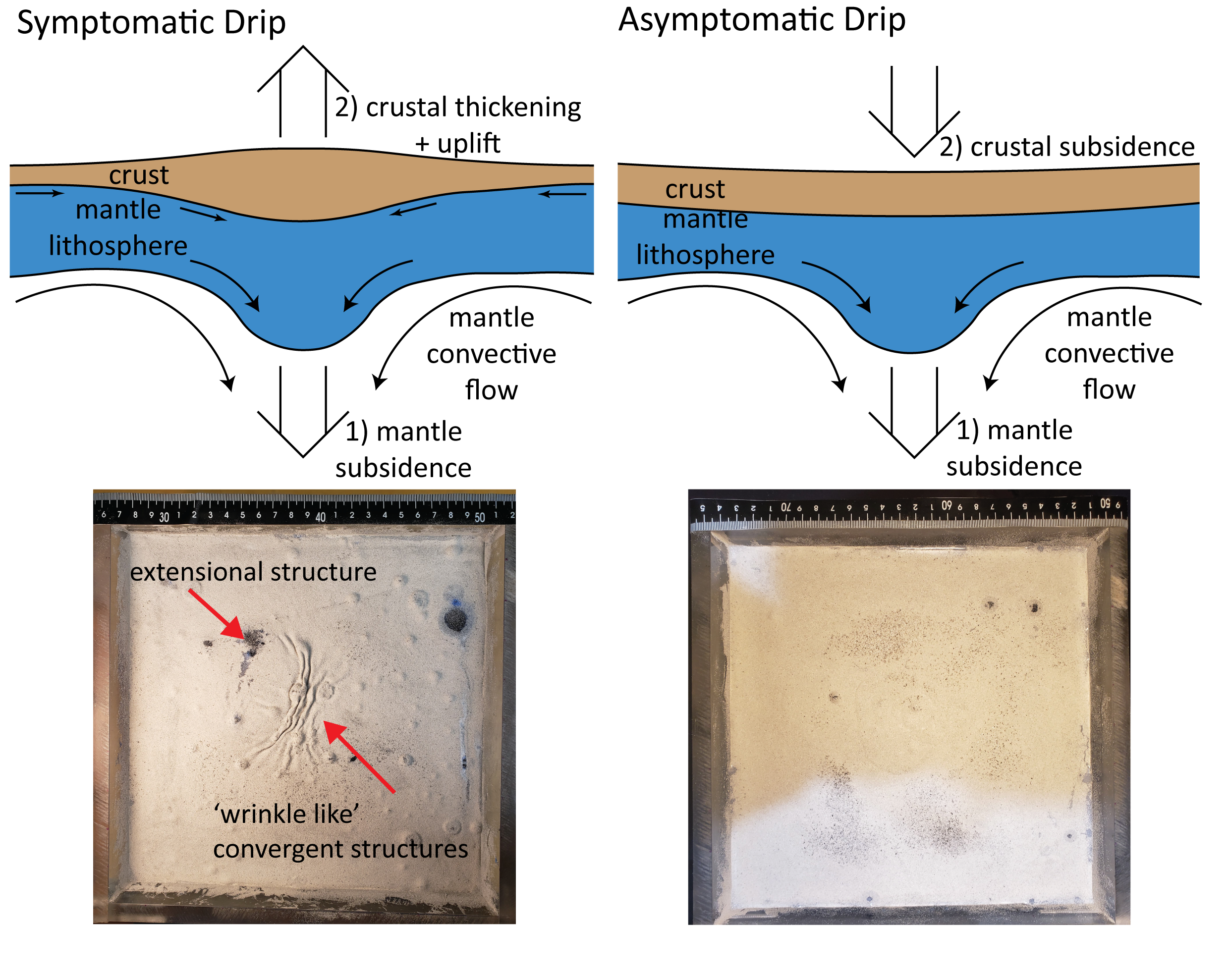
Artist impressions of two types of lithospheric drip, supported by surface views of the experimental simulation of the processes. One produces thickening and uplift of Earth’s crust, while the other results in the formation of a basin at the surface. (photo by Julia Andersen/Tectonophysics Lab/University of Toronto)
“We compared our model results to geophysical and geological studies conducted in the Central Andes, particularly in the Arizaro Basin, and found that the changes in elevation of the crust caused by the drip in our models track very well with changes in elevation of the Arizaro Basin,” Andersen says. “We also observed crustal shortening with folds in the model as well as basin-like depressions on the surface so we’re confident that a drip is very likely the cause of the observed deformations in the Andes.”
The researchers suggest the findings aim to clarify the link between mantle processes and crustal tectonics, and how such geodynamic processes may be interpreted with observed or inferred episodes of lithospheric removal. “The discoveries show that the lithosphere can be more volatile or fluid-like than we believed,” says Pysklywec.
Additional contributors to the study include Tasca Santimano, of U of T’s department of Earth sciences, and Oguz Göğüş at Istanbul Technical University and Ebru Şengül Uluocak at Çanakkale Onsekiz Mart University in Turkey.
The research was made possible thanks to support from a Discovery Grant from the Natural Sciences and Engineering Research Council of Canada, the International Fellowship for Outstanding Researchers Programme of the Scientific and Technological Research Council of Turkey, a TUBITAK Fellowship for Visiting Scientists, as well as Compute Ontario and the Digital Research Alliance of Canada.


