The 153,415 hectare Narriearra Station in far north west NSW is the largest purchase of private land for national parks in the State’s history.
Environment Minister Matt Kean says the purchase will help protect threatened species, important habitat and wetlands.
“Narriearra Station stretches across the outback Channel Country and includes part of the Bulloo River floodplain, ephemeral wetlands and landscapes currently not found anywhere in NSW national parks,” Mr Kean said.
“Narriearra is an important refuge for threatened wildlife, with more than 25 threatened animal species, including nearly 90 per cent of NSW’s critical habitat and breeding areas for the nationally endangered Grey Grasswren.”
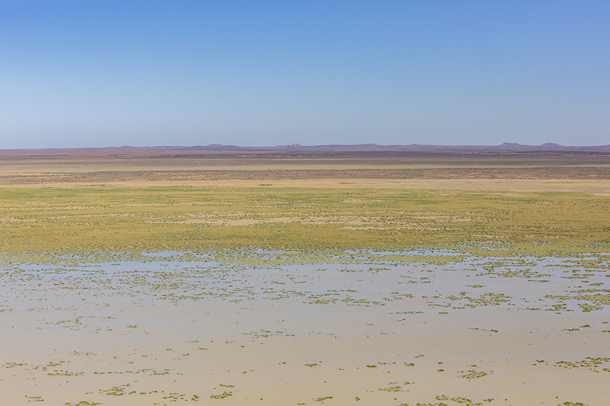
Mr Kean said the acquisition secures a key section of a nationally important wetland – the Caryapundy Swamp – which can host tens of thousands of waterbirds including pelicans, straw-necked ibis, egrets and whiskered terns during inland flood events.
“Narriearra along with the nearby Sturt National Park, will create a vast near-contiguous conservation area of almost half a million hectares, or twice the size of the ACT.
“Adjoining the Pindera Downs Aboriginal Area, Narriearra contains many significant and valuable stone artefacts, tools and stone arrangements.
“The property is also linked to the ill-fated Burke and Wills expedition, with two expedition campsites on the property.
“In August last year I stated my goal to add 200,000 hectares of land to the national parks estate. I am ecstatic that, on top of 64,860 hectares already reserved, this purchase puts us on track to exceed that.”
The Minister has invited the Tibooburra Local Aboriginal Land Council to suggest a name for the new national park.
General description
Narriearra is in the far north west corner of NSW, just east of Tibooburra, within the Channel Country Bioregion. The property’s northern boundary follows the NSW/Qld state border along the dog proof fence. It is to the east of Sturt National Park.
The iconic Bulloo River is a feature of this desert property, flowing south from Queensland and terminating on Narriearra in an expansive area of floodplain and vast ephemeral wetlands known as the Bullo Lake, Caryapundy Swamp and the Bullo Overflow.
In addition to the ephemeral wetlands resulting from the flood-out terminus of the Bullo River, the property contains a diversity of broad ecosystems including: aeolian dunes supporting both acacia and saltbush shrublands, sandplain grasslands, chenopod shrublands, gibber rises and coolabah lined channels. The wetlands feature large semi-permanent lakes dominated by lignum and cane grass communities, intermittently capable of hosting mass communal nesting events for waterbirds and other wetland fauna.
Key facts
- Size: largest ever private acquisition for the national park estate – 153,4155 ha
- Bioregional significance: Narriearra makes a significant contribution to a comprehensive, adequate and representative reserve system by:
- Increasing the level of protection for the Channel Country Bioregion from 6.6% to 15.4%
- Protecting an area of two subregions (Bullo and Central Depression subregions) which are currently not represented in the national park estate.
- Protecting 3 landscape types that are not protected in any other national park.
- Complementing the nearby Sturt National Park – four of the landscapes occurring on Narriearra Station do not occur within Sturt National Park; there is a broad transition from arid wetland communities on Narriearra to gibber, shrublands and woodlands on Sturt NP.
- Ecosystems: Narriearra protects a remarkable diversity of ecosystems – 39 Plant Community Types are mapped.
- Threatened species: more than 25 threatened fauna species are present on the property including:
- Nearly 90% of the remaining habitat in NSW for the endangered Grey Grasswren.
- Other threatened species include the Grey Falcon, Redthroat and Australian Bustard.
- Wetlands: the property includes 24% (58,500 ha) of the unreserved ‘Bulloo Lake’ which is listed in the Directory of Important Wetlands in Australia and includes the Caryapundy Swamp and southern outflow to the Bulloo Overflow
- Aboriginal heritage: stone artefacts, tools, and stone arrangements provide evidence of Aboriginal occupation over the entire property.
- European heritage: the site was traversed and documented by the ill-fated Burke and Wills expedition with two expedition campsites on the property. Tongowoko ‘waterhole’ on the eastern border (Camp 48) on Friday 2 November 1860 and at Caryapundy Swamp on Saturday 3 November 1860. The location of the Camp 48 was marked by engraving on a tree “B over XLVIII”. There is currently an engraved post marking the site.
“There are great numbers of water fowl about the swamp. Ducks, water hens, snipe and a small white long-legged bird of the crane tribe.” Extract from Wills Journal, November 1860


