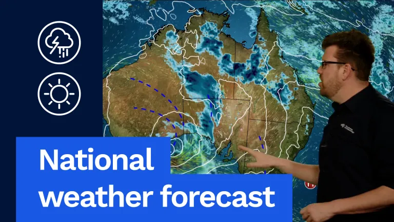
And it’s all about this low-pressure system in the Great Australian Bight. That’s bringing rain and thunderstorms through much of central Australia. Hot, humid and stormy conditions through northern Australia as well, warming up with afternoon showers and thunderstorms also through south-eastern parts of the country later in the day and into Thursday night.
Well, a much calmer Thursday on the way for many parts of WA, as our weather focus shifts towards central and then south-eastern Australia. But let’s look at all of that in more detail.
Firstly, in Queensland we can see showers and thunderstorms continuing along that trough line, basically from the north-west all the way down into the south-east. Then our focus really will be through western and northern parts of Queensland, where we’re going to see widespread showers and thunderstorms here, as you can see in the blue highlighted areas. That’ll also keep temperatures a little bit cooler than what we have seen. So, we’re seeing temperatures more in the low to mid 30s, rather than high 30s and low 40s, except for the far north, where Weipa are continuing to have a record run of heat up there. Coastal areas pretty much around the 30 °C mark, and a little bit cooler and continuing the drier trend in south-eastern Queensland as well. So, showers and thunderstorms, some possibly severe for northern and western Queensland. Fine in the south-east. Brisbane looking at a partly cloudy day and 27 °C.
Moving down into New South Wales, and it’ll start off as a pretty warm and dry day, and pretty warm actually, with temperatures in the low to mid 30s for many of our inland areas. But notice these showers and thunderstorms on the ranges, and widespread showers and thunderstorms developing through inland areas of New South Wales during the afternoon and evening hours. Coastal sea breezes will keep a lid on temperatures on the coast, so only looking in the mid to high 20s for our coastal areas, but quickly warming up into the low to mid 30s everywhere else. Sydney looking at a lovely day, 27 °C, afternoon sea breezes and lots of sunshine, 27 °C.
Canberra afternoon showers and possibly thunderstorms late in the day into the evening, 29 °C. But our focus really will be the hot, humid and stormy weather through western New South Wales Thursday afternoon and evening.
Victoria, similar conditions, warming up after what’s been a very cool week for many areas. Temperatures in the low to mid 20s in the south, low to mid 30s in the north. We can see these blue dots popping up during the afternoon and evening hours. That’s as we become a bit more unstable and humid ahead of that approaching low-pressure system and trough in the Great Australian Bight. That’s probably going to drive some showers and thunderstorms through western and northern parts of the state during the afternoon and evening, and also through eastern areas as well. It will stay dry in the south, though, with temperatures, as I mentioned, in those low to mid 20s. You’re getting pretty hot in the north along the Murray before those showers and storms, temperatures getting up into the mid to high 30s. Melbourne looking at a possible shower, particularly late in the day towards our far northern and eastern suburbs. 25 °C, but mostly a warm, partly cloudy day otherwise.
Moving down into Tasmania, and it’s a mild to warm one with lots of sunshine, just a few puffs of cloud here and there during the day, but really it should be a lovely day for many. Temperatures in the low to mid 20s, getting into the high 20s in some of our inland northern areas as well. We may see cloud increase later in the day in the west with an offshore shower or two. Hobart looking at a partly cloudy day and 21 °C. A lovely day to get out and about.
Now, South Australia going to be the main weather state on Thursday. We’re going to see widespread showers and thunderstorms developing through much of the state, particularly through central, eastern and northern areas, during the afternoon and evening hours. Now, some of these thunderstorms could be severe as well, particularly through the Eyre Peninsula and up through the pastoral districts as well during the afternoon and evening. That could include large hail, damaging winds and heavy rainfall as well. Now, those thunderstorms will reach eastern parts of the state during the late afternoon and evening hours. Probably not going to be as severe as further west, but still could bring some bursts of heavy rain and gusty winds. Warm as well, ahead of that. Temperatures in the low 30s through southern parts of the state, mid to high 30s through northern and inland areas as well. Adelaide looking at a fine start and a very warm morning as well, low 20s and then a warm to hot day, 31 °C, with those afternoon showers and thunderstorms moving in during the afternoon and evening. 31 °C.
Now moving to WA. It’s been an active few days through these areas, but much quieter conditions on Thursday. As you can see, this trough and low-pressure system moving out of the region. Still mild though for many of us. Temperatures in the low to mid 20s. A little bit cooler for our coastal areas with southerly winds, but mild further inland and across the Wheatbelt and also into northern areas as well, as we’re getting pretty warm up in the Pilbara, as you’d expect, temperatures in the high 30s. Dry and partly cloudy for many. Perth looking at 25 °C and partly cloudy skies.
Now, moving up into the Northern Territory. As you expect this time of year, widespread thunderstorm activity for much of the day. Some of those could be severe, with heavy rainfall and damaging winds, particularly through central and southern areas during the afternoon and evening, and widespread showers and thunderstorms from the Pilbara, Top End and into Cape York as well. Temperatures low to mid 30s in the south, high 30s to low 40s through inland areas, particularly through the Kimberley and the Top End, and coastal areas up in the north in the low to mid 30s and very humid as well. Build-up conditions continuing. Darwin looking at 34 °C and, as usual, possible afternoon showers and thunderstorms, and that could continue into the evening.
So, with an active day of weather around the country on Thursday, and maybe even a bigger day in south-eastern Australia on Friday, remember to get the latest forecast and warnings for your area, via our website, app and social media, and I’ll be back here again tomorrow with your Friday forecast.
Video current: 1:00 pm AEDT Wednesday 18/11/26.