Seismic waves from a 2010 earthquake more than 600 km under Spain were the clues leading to an unexpected discovery of a subducted oceanic plate that had flipped over, according to new research from The Australian National University (ANU).
The waveforms show a plate beneath the western Mediterranean that descended rapidly into the Earth’s mantle and overturned so that the water it carried as it sunk is now further below the surface.

Study co-author Professor Meghan Miller, a seismologist at the ANU Research School of Earth Sciences, said it’s the first time a subducted plate has conclusively been shown to behave in this way.
“The oceanic lithosphere – the solid, outermost part of the Earth – has turned on top of itself, so it’s rolled over, and this is the first time that it’s been imaged in such detail,” she said.
“Our study is the first to conclude that the slab has overturned rather than vertical or steeply dipping.
“These new insights give a fundamental understanding of how our planet has evolved over time.”
Seismologists have been measuring the Earth’s interior for decades, most commonly through tomography, a “CT scan” of the Earth’s surface.
The result is often low-resolution, providing a blurry image of what’s happening in the Earth’s interior. By applying a different method combining traditional and modern approaches to analysing waveforms, the researchers came face-to-face with the unexpected discovery of the subducted slab.
“We took a different approach and weren’t looking at tomographic models but at individual waves in a seismogram, a more ‘old school’ technique in which you can observe the detailed changes in the waveforms,” Professor Meghan Miller said.
“By looking at how the waveforms differ from what’s expected, we discovered detailed structures deep inside the Earth.
“This blend of traditional methodology and new high-performance computing led us to the fine-scale imaging where we saw the structure and morphology of this unique subducted slab, which was very unexpected and exciting.”
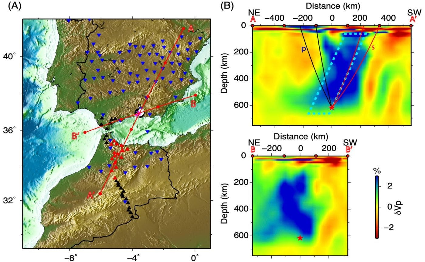
The study might also shed light on the mechanisms behind rare and deep earthquakes (more than 600 kilometres below Earth’s surface) in southern Spain and elsewhere on the planet.
Seismic waves from one of those earthquakes, a magnitude 6.3 earthquake that occurred below Granada in April 2010, were captured by an array of seismic stations in Spain and Morocco.
Co-author Professor Daoyuan Sun, from the University of Science and Technology of China, added: “Our study could help researchers sort out the complicated tectonic structure of the western Mediterranean basin where Africa and Eurasia are converging, specifically an area called the Rif-Betic-Alboran region.
“This region contains an arc formed by the Betic mountain ranges in Spain and the Rif Mountain ranges in Morocco and includes the Alboran Sea basin just east of the Strait of Gibraltar.”
The researchers say it would be promising to investigate the seismic waveforms produced by deep earthquakes in other places, such as northeastern China, South America, Indonesia and places like the Fiji-Tonga region, to see if similar mechanisms are at work.
“But the research would require dense seismic stations deployed right above these earthquakes, as was the lucky case with the 2010 Spain earthquake,” Professor Miller said.
The research findings are published in The Seismic Record.


