Although it is typically after the shortest day of the year when we see our coldest weather, even though those days are now getting marginally longer, we will have a chilly start to Tuesday.
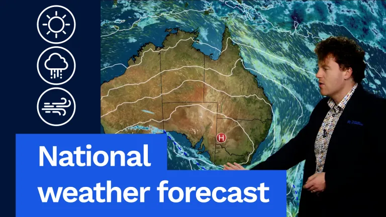
After that chilly, slightly wintry start for many areas, it will be a fairly settled and sunny one, though high pressure is certainly the major player through the weather this week. We’ve got one high here, another high stretched out across the south-west, and high pressure does bring settled weather. That means dry conditions for the vast majority of the nation.
Rainfall really at a minimum across the country tomorrow, just a little bit down here through parts of the south-east and a few other coastal regions.
Going state by state, starting in Queensland. It will be a cool morning, particularly up in the Downs where we’re likely to have some low single-digit temperatures and possibly some frost on Tuesday morning. After that, it will be a beautiful, bright, sunny day nearly statewide. A few showers around the North Tropical Coast passing through at times. Dry everywhere else. For Brisbane and the rest of south-east Queensland, a slightly cooler morning but a beautiful sunny afternoon without much wind.
Also a little wintry for New South Wales on Tuesday. A crisp morning that’ll lead to some areas of frost, particularly on the slopes of the Great Dividing Range. Some areas of fog could impact really anyone tomorrow morning, but that should all clear up and a bright sunny day will stick around after that. When it comes to the temperatures, somewhere near average for the time of year. Sydney tracking for a high of 18 °C with a fine afternoon.
Canberra a little cooler, a high of 13, but should see plenty of afternoon sunshine as well.
A similar story for Victoria. Some frost, some fog in the morning, but that will burn off fairly fast and then sunshine will come to dominate the remainder of the day. Temperatures are a little bit cooler, lots of places not even reaching 15 °C tomorrow, but there won’t be too much wind, so don’t expect a wind chill factor to play into that. A couple of spots could see some afternoon or evening showers, particularly along the south-west coast from Portland, Warrnambool down towards the Otways, and maybe around Wilsons Prom and even up to parts of the Mornington Peninsula. We could get a late shower. Other spots, including Melbourne, ought to stay dry.
A cold front actually is crossing Tasmania tomorrow morning. We’re going to see a spell of rain across most of the state through Tuesday morning, including for Hobart. Into the afternoon, the rain will clear out of the south, but we could see the odd shower stick around to the north, including Launceston, well really right across the coast out towards Burnie. Temperatures 15 °C or lower across the state. Unfortunately, Hobart at the low end of that scale, a high of 11 °C. Some sunshine coming through after that morning rain clears.
A crisp, fresh winter’s morning for South Australia. Very little wind, maybe a little fog. The sun should come out and it will be a pleasant afternoon, but those temperatures will stay fairly limited given the time of year and the cold air. An evening shower or two possible around the Limestone Coast, about Mount Gambier, also possibly on Kangaroo Island. All other locations ought to stay dry.
Out to the west, a fairly fine day out this way as well. Temperatures will start off slightly chilly, but warm to something at least seasonal, if not slightly above average in many areas. Perth heading towards a sunny afternoon, a nice high of 21 °C there. A few light showers around the Eucla coast pushing up towards the Goldfields and southern interior as well. Don’t expect anything significant to land in the gauges there. It is bright, clear and sunny everywhere else, including way up here in the Pilbara.
And we might see some low temperatures around central Australia tomorrow. We’ve got 2 °C as the minimum in Alice Springs, but I think some parts of southern NT could be closer to 1 °C or even 0 °C. As we kick-start things on Tuesday morning, it will be a fine, bright day without much wind. Temperatures in the north are more seasonal. We’ve still got those minimums around 20 °C in Darwin. Certainly cooler as you drive southwards, but afternoon maximums around the 30 °C mark.
Stay up to date with the latest on the Bureau’s website or app. Thanks for sticking with me and have a wonderful day.
Video current: 12:30 pm AEST Monday 22/06/26.


