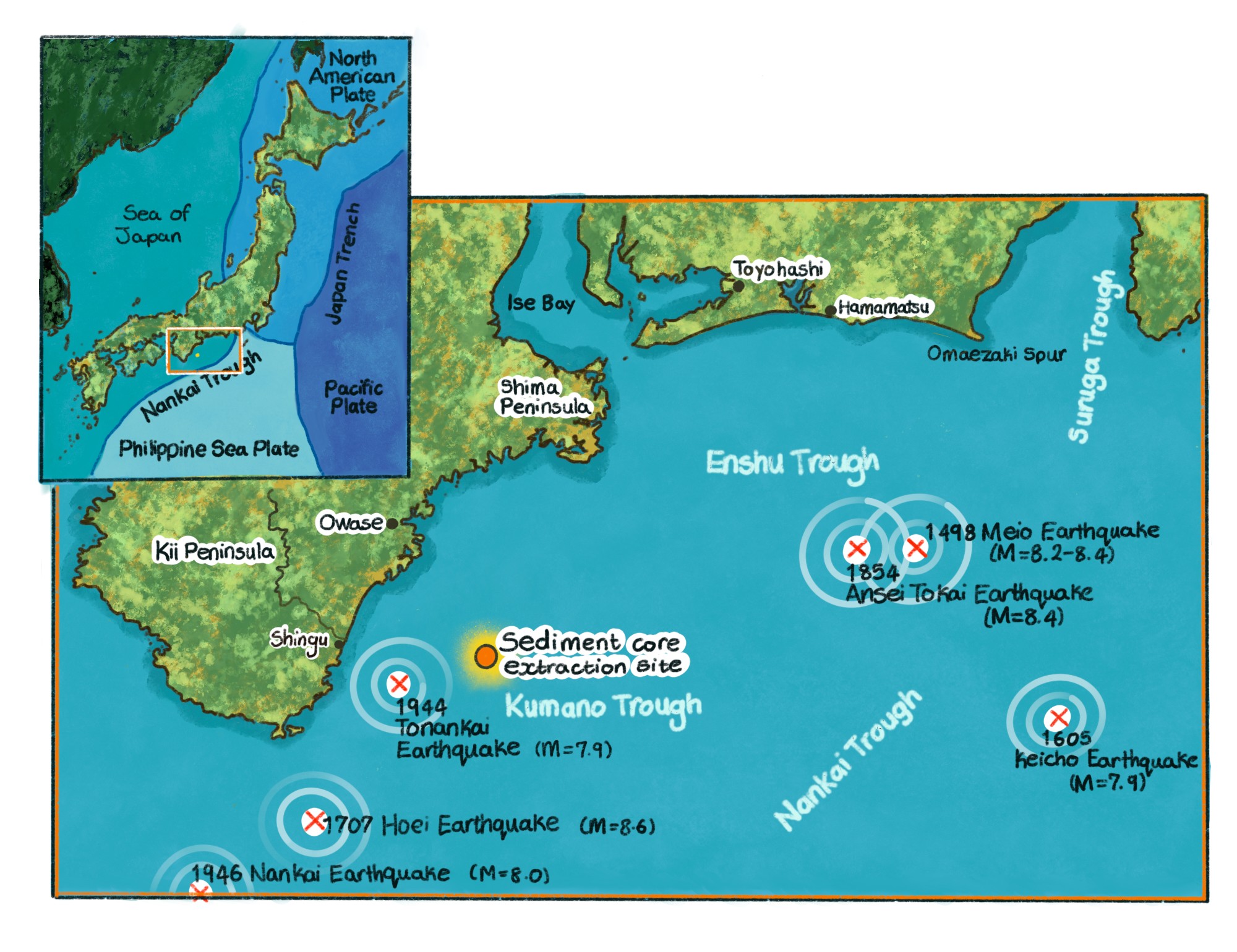
Researchers at the University of Tokyo have used a new type of radiocarbon analysis to study a sediment core taken from the Kumano Sea off the coast of Japan. This has revealed multiple “hidden” traces of previously unknown earthquakes in the Nankai Trough, where the country’s next megaquake is expected to occur. Reconstructing a more accurate picture of the past will help with the prediction of future geophysical events and to prepare for potential disasters.
Japan is well known for its history of tsunamis, earthquakes and typhoons. Modern monitoring and warning systems, along with advances in infrastructure and disaster preparedness, mean that the damage dealt by these natural forces is vastly different nowadays compared to the past. Even so, the more accurate our picture of historical events is – their location, scale and reoccurrence – the better people can prepare for the future, especially as another megaquake is anticipated in Japan within the next 30 years or so.
Natural disasters leave evidence of their earth-shifting movement within the geological record, but not all events are easy to spot. A team from the University of Tokyo has used a new type of radiocarbon analysis to study a sediment core taken from the Kumano Sea, hoping to find signs of historical earthquakes that conventional techniques have previously been unable to detect.
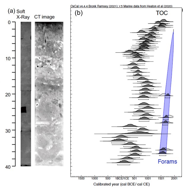
“We found several new geological layers that were not visible before, derived from submarine landslides possibly triggered by earthquakes in the Nankai Trough,” explained Professor Yusuke Yokoyama from UTokyo’s Atmosphere and Ocean Research Institute. “We used a new, ultrasensitive method to measure the trace amounts of carbon-14 contained in sediment from the ocean floor, at a very high resolution of 1 centimeter or less. This revealed multiple events which were not found through previous visual observations, X-ray or CT analysis.”
Despite the minute quantities of carbon-14 on Earth (making up just one-trillionth of natural carbon), it is a very useful substance for research as it decays at a known rate. All biological things absorb carbon-14 while they are alive, and it can be measured in samples which contain remains from plants, animals or their derivates. Researchers can date a sample back as far as 50,000 to 60,000 years, depending on how much decay has occurred.
The ocean sediment core used in this study was a 40-centimeter-long cylinder extracted from the Kumano Trough, off the southeast coast of central Japan. Made up of fine-grained clayey silt, the team took radiocarbon measurements of total organic carbon at 0.5- to 1.0-centimeter intervals along the length of the core. The oldest part of the core was dated back to approximately 1440 C.E. (at a depth of 37-38 cm).
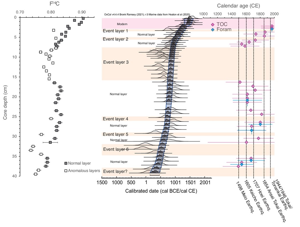
Geophysical events were marked out by instances of older organic carbon being found mixed in between layers of younger sediment, which the team interpreted as evidence of seafloor sediment being disturbed, shifted and repositioned due to severe floods, storms or submarine earthquakes.
“Because the redeposited sediments are the same as the materials below, the chemical and structural features were indistinguishable, making the event layers invisible,” said Yokoyama. “However, by identifying differences in the total organic carbon ages along the length of the core and converting these to calendar years using ages obtained from forams (microscopic marine organisms with shells), we could determine the occurrence of multiple events and were able to correlate some of these with written historical records of submarine earthquakes from the 13th to the 20th century.”
This new technique is useful not only for Japan but other regions with a history of geological activity that are seeking more data to improve their predictions. Yokoyama is now interested in looking not just deep in the ocean but also more widely across the Kumano Sea and beyond, to piece together the broader picture of Japan’s hidden history of disaster and prepare the nation for future events.