Ever opted to take the stairs over the lift for the sake of additional exercise? You’ll be pleased to know that on reaching the top, you’ll appear to weigh an average 100 mg less than what you did at the bottom!
Think that’s impressive? Try 2.4 grams less if you first weighed yourself in South East Cape Tasmania, and then in Cape York, Far North Queensland – fact! Why? According to Geoscience Australia’s Geophysicist Richard Lane, it all comes down to gravity.
“Gravity decreases as you get further away from the centre of the Earth, hence you will feel lighter when you climb some stairs or travel towards the equator where there is a bulge in the radius of the Earth,” says Richard. “For us at Geoscience Australia, we’re particularly interested in gravity because it also varies depending on the type of rocks and the amount of water that’s underground.”
“When it comes to working out what’s going on underground, we combine gravity information with data from other geophysical tests or surveys such as those measuring changes in the Earth’s magnetic field, and the electrical conductivity of rocks and groundwater. Together, the different measurements tell us what energy, mineral and groundwater resources are beneath the surface,” says Richard.
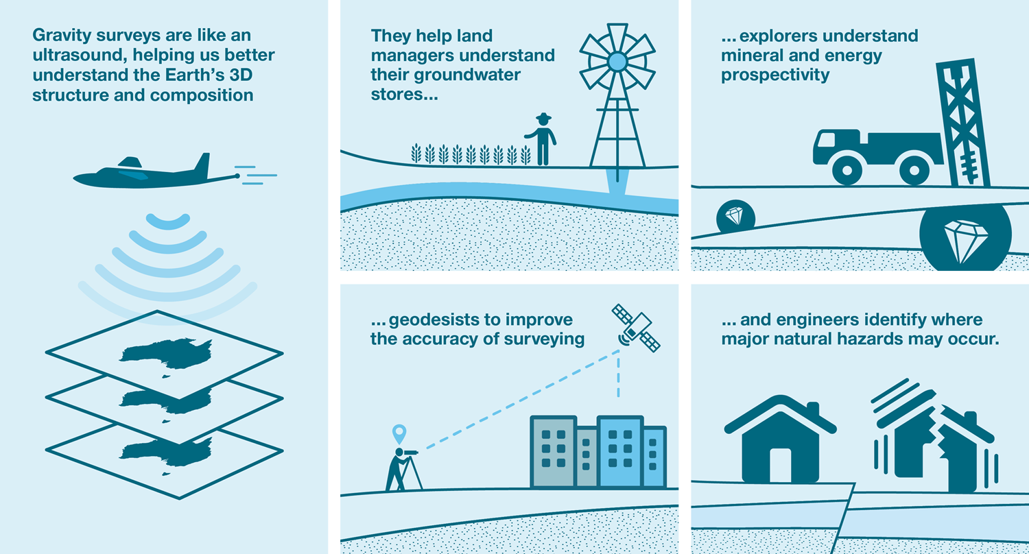
Data from gravity surveys is used in conjunction with that from other geophysical tests to help a variety of individuals from a whole range of sectors.
Once the measurements have been taken, data crunched, integrated with other results and reports written, the information is ready for distribution to the public. As to who uses this information, Richard explains “it’s a variety of individuals from a whole range of sectors, including:
- mineral and energy exploration companies deciding where to explore
- geodesists improving the accuracy of their surveying methods
- land managers obtaining a broad knowledge of groundwater stores, and
- engineers identifying major natural hazards.”
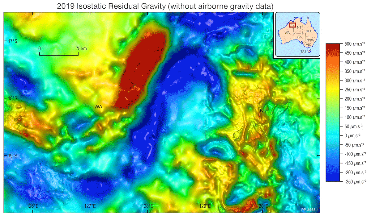
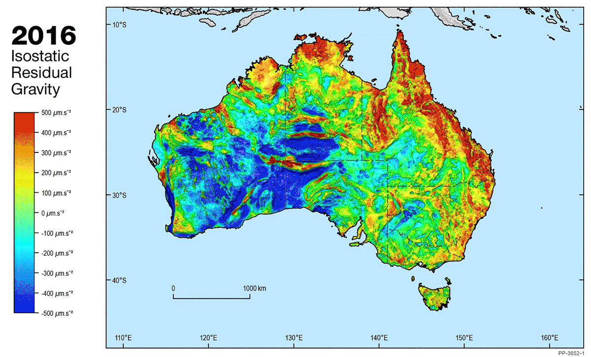
“Those interested in using gravity for geological mapping, exploration and geophysical modelling will be excited to learn that Geoscience Australia has just released the largest, most accurate gravity dataset to date,” says Richard.
“Released in October 2020, the 6th edition of the National Gravity Grids has been extended to include fully processed data for offshore areas for the first time. These new grids cover almost 24 million square kilometres – an area over 300 per cent larger than the previous edition.
“It is also the first dataset that combines onshore, offshore and airborne gravity data, resulting in more accurate data for users.”
The video below provides a comparison between the previous gravity data and the new, showing a much clearer picture of the underlying geology across Australia.
Richard said the information in the new National Gravity Grids will change our understanding of Australia’s geology.
“Gravity data is an important tool for governments and the exploration sector to understand Australia’s geology. This allows us to make more informed decisions on the resources beneath our feet, such as minerals, energy and groundwater,” says Richard.
“Understanding gravity is important for other applications as well. Surveyors use this type of data when they plan infrastructure projects and smartphones use gravity data to help people to navigate from place to place.”
Geoscience Australia works with state and territory governments to acquire and maintain the gravity data used in the grids.
“Our role since the 1940s has been to maintain the Australian National Gravity Database, which contains data from ground gravity surveys conducted throughout Australia and its Remote Offshore Territories,” explains Richard.
“We have recently started to acquire and maintain airborne gravity data. The use of aircraft allows us to obtain gravity data more quickly over remote areas that would be difficult to access on the ground.
“These data were used for the first time in the latest National Gravity Grids and they are adding exciting new detail.”
“Geoscience Australia also maintains the Australian Fundamental Gravity Network (AFGN), a network of over 1000 stations that was critical for ensuring that the data from more than 1300 different surveys that were used in the National Gravity Grids could be combined seamlessly,” says Richard.
A new web interface to the AFGN was released in October 2020. It allows those involved in gravity acquisition to search for and download the important facts for the nearest AFGN stations to their survey area.
The National Gravity Grids are available free to download at:
- ECat: https://pid.geoscience.gov.au/dataset/ga/133023
- GADDS2: https://portal.ga.gov.au/persona/gadds
The new grids can be downloaded individually, as one large package or according to a region-of-interest. A Geoscience Australia Record providing the technical details behind the grids can also be found here:


