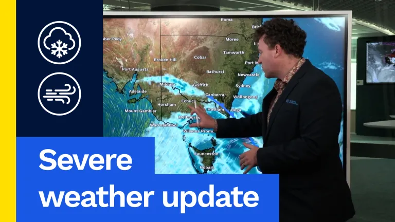
So how does that look on our weather forecast? Well, we will see some rain as this weather system moves up and across the south-east during the second half of Friday, overnight into Saturday morning. For most places it won’t be that much rain. We could see some moderate falls, perhaps 20-30mm for western Tasmania and eastern parts of Victoria around Gippsland, but most people will get less rain than that. Rain is not really at the forefront of this weather event. That said, it will be a little bit damp through most of Victoria and Tasmania late Friday and into the early hours of Saturday morning, as well, but it’s not really the rain we’re concerned about. It’s the temperatures, it’s the cold. Here’s Saturday’s maximum temperatures just 13 to 16 °C across Tasmania and Victoria. Colder than that if you live at elevation and I have to say these max temperatures for Saturday, don’t even tell the whole story because there’s going to be a brisk south-westerly wind. There’s probably going to be intermittent showers that come and go. Both of those are going to make the feels-like temperature colder than what we actually see on the thermometer. So if you’re actually spending significant time outside this weekend, particularly on Saturday, it’s probably going to feel more like 8 to 10 °C. A bit of a nasty interruption for our final month of spring. There will be some snow. That’s what happens when we get cold air and rainfall together. There’ll be snow across most elevated parts of Tasmania, snow for eastern Victoria and south-eastern New South Wales as well. Here’s a little indication of how low that snow could get. The lowest snow will be in the deep south, far southern Tasmania, where that snow level sits at about 400m. That’s not too much of a worry if this were the middle of winter, but that is unusually low snowfall for November. Northern parts of Tasmania could see snow at about 700m and higher. Eastern parts of Victoria and south-east of New South Wales, 800m. That’s a low snow level for the mainland that could be affecting some higher mountain passes and maybe some hiking routes up in the ranges there. And even further north, we could see a dusting as far north as the Central Tablelands or Blue Mountains, just on those very highest peaks, spots like Mount Conbolas where that snow could settle above about 1200m. So that’s what we’re looking at for Friday and into Saturday morning. Cold, potentially snowy, quite wintry outbreak.
But now I want to focus on Saturday during the day for the east coast of New South Wales. The same weather system will be racing northwards up the New South Wales coast, with a bit of a stronger signal in behind it for some potentially moderate or even briefly heavy rainfall, as this weather system does move northwards. But you might be a touch confused. Perhaps you notice before the maximum temperature in Sydney is 30 °C on Saturday. Well, that’s true because most of the day, at least a good chunk of the day is going to be warm, probably sunny, maybe a little bit breezy, but feeling really quite summery through Sydney as well as Wollongong as well as Newcastle through much of the day on Saturday. But that is going to change rapidly once the weather system arrives. In fact, the 30 °C day is giving us some high to extreme fire danger over New South Wales for most of the day before that rain arrives. It is hot, it is windy and that’s what drives elevated fire danger. But a big shift coming when the wind changes to the south. We can see that coming up here, it’s a strong wind for the coast as well. Likely to reach Sydney about 4 p.m. and that is when everything is going to flip on its head. Temperatures will plunge perhaps from 30 °C down to maybe 18 or 19. You could lose more than ten °C within half an hour. We also see the rain arriving as that moves northwards through the afternoon. That will be a couple of hours later in Newcastle, and by the time we reach midnight up through the mid-north coast, perhaps to about Coffs Harbor. But we will certainly be seeing those cold conditions sit in right across the east coast of the state.
One more thing to throw in the mix for the New South Wales coast, including Sydney, as that wind change arrives, not only does it bring the cold, strong wind, but it also brings a risk of thunderstorms. This is our thunderstorm forecast for Saturday. Notice this yellow area hugging the New South Wales coast. That extends all the way from the south coast around Narooma, up to the mid-north coast around Port Macquarie, including all of our highly populated parts between the Illawarra and the Hunter. Now we’ve got the severe thunderstorm risk shown in yellow, because storms moving through with our change tomorrow could bring particularly powerful, potentially damaging wind gusts where we could see winds for exposed locations reach 90 or 100km/h. Maybe bringing down some branches or even trees and potentially causing a bit of property damage as well. So definitely something to keep in mind as we head into the weekend. It might feel warm, sunny and summery, but you’ve got a nasty change on the way.
Start up to date with your local forecast and any warnings that do get issued on the bureau’s website or the BOM Weather app. Thanks for watching. Have a safe weekend.
Video current: 12:00 pm AEDT Friday 06/11/26.