cut-off by floodwaters.
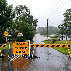
The City of Logan is bracing for major flooding after two days of heavy rain.
Localised falls of more than 220mm have been recorded over the past 24 hours and further intense falls are expected today, but possibly easing this evening according to the latest forecast.
The Logan River at Maclean Bridge is expected to peak today above the major flood level at 20.5 metres.
In comparison the 2017 flood peak was 23.97 metres.
The Logan River at Waterford is likely to exceed the major flood level at 9 metres on Monday morning. In 2017 the level reached at Waterford was 10.5 metres.
Emergency alerts have been issued for 16 suburbs including and Council is door knocking residents in the worst-affected streets.
Property close to a river or creek in Chambers Flat, Logan Reserve, Waterford West, Waterford, Loganlea, Meadowbrook, Tanah Merah, Loganholme, Eagleby, Mount Warren Park, Bannockburn, Windaroo, Beenleigh, Holmview, Edens Landing and Bethania are at risk.
All City of Logan residents are asked to conserve water due to the extreme weather impacting the Mt Crosby and North Pine water treatment plants.
Residents who have been without electricity for an extended period should practise food safety precautions.
City of Logan Mayor Darren Power urged the local community to be prepared and take all necessary precautions to stay safe.
“The Logan community is resilient and has been in this situation before, but we need everyone to be vigilant,” Councillor Power said.
“Parts of the city are already isolated and we expect more locations to be cut off later today.
“If your suburb has a history of impact from a rising waterway, get prepared to be cut-off or consider moving to higher ground ahead of any forecast flood peak.
“Those not impacted by flooding should stay at home today.
“We don’t want people driving or wading through floodwaters or going out to sightsee. If it’s flooded, forget it.”
Isolated communities include:
- Logan Pde, Logan Reserve with Schmidt Rd under water. This community may be isolated for several days.
- Bayes Road in Logan Reserve (seven properties).
- Properties in Logan Village/Cedar Creek and Wolfdene after Miller Rd was flooded this morning. Latimer Rd, Vievers Rd, Plunkett Rd and Beenleigh-Beaudesert Rd were previously closed.
- There is potential for communities within Yarrabilba, Logan Village and parts of Stockleigh to become isolated.
Those residents whose properties may be inundated are advised to:
- Secure objects that could float and stack furniture and possessions as high as possible
- Chemicals, poisons and garbage should be moved to a high place


