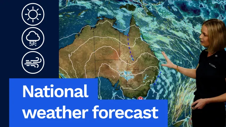
So we’ll start off by taking a look at tomorrow’s weather map.
We have this strong and slow-moving high-pressure system over the south-east, bringing settled weather with morning fog and frost patches.
But it’s also directing this moist onshore wind to the east coast with hit-and-miss showers, while an inland trough brings unseasonal showers and storms.
Out in the west this strong cold front will bring a return of the wet and windy weather.
So let’s go around the country now, taking a closer look.
Starting off with Queensland.
We’ve got some scattered showers and possible storms that will develop through the south-west during the day.
And then as we head into the evening, there’s even the potential for some light patchy rain to develop about the Maranoa and Warrego districts.
Further east, isolated showers are also possible through the central and southern interior.
For Brisbane, a partly cloudy day with a shower or two, a top of 20°C.
Down in New South Wales, those scattered showers and possible storms extend across the state throughout the northern inland plains, and there’s also scattered showers about the central and northern coasts.
Isolated showers elsewhere, with daytime temperatures in the mid to high teens.
For Sydney, a partly cloudy day with showers and a top of 17°C, while for Canberra, morning fog patches clearing to a partly cloudy day and 14°C.
Down in Victoria, it’s going to be a chilly start, with morning fog patches possible across the state and even the risk of some frost patches through north-eastern districts.
Generally dry, with just one or two showers on and south of the Divide, with daytime temperatures in the mid-teens.
For Melbourne, morning fog patches clearing to a partly cloudy day with a top of 14°C.
Heading down to Tasmania, it’s a generally dry day with light winds, with just the chance of a very light shower about the far west.
Maximum temperatures in the low teens.
For Hobart, a partly cloudy day with light winds and a top of 12°C.
Up in South Australia, morning fog patches are possible through south-eastern parts, and also even the potential for some light showers about the Flinders and Southern Pastoral districts.
Daytime temperatures in the mid to high teens.
For Adelaide, a partly cloudy day with the potential for some morning fog patches, a top of 16°C.
Now over in WA, we’ve got this cold front that will bring that wet and windy weather moving eastwards throughout the day, but there is the potential for a severe thunderstorm through the south-west, bringing damaging wind or heavy rainfall.
For Perth, a cloudy day with showers and the potential for a gusty storm to bring heavy rainfall, a top of 18°C.
Up towards the Northern Territory, a generally dry and sunny day apart from just the risk of a shower about the Top End.
For Darwin, a sunny day and a top of 32°C.
Now, if you’re wanting a more detailed forecast for your local area, you can get that via the Bureau website or the app.
Otherwise, we’ll see you again tomorrow. Bye for now.
Video current: 12:30 pm AEST Thursday 25/06/26.


