With the return of La Niña to Australia, it’s more important than ever for emergency managers and communities to be better prepared for severe weather.
The 2020 Tropical Cyclone Outlook, recently issued by the Bureau of Meteorology, indicates that as we enter a La Nina weather cycle this season Australia can expect to have more tropical cyclone events compared to previous years.
Geoscience Australia is working with state emergency managers to investigate the likelihood and potential impacts of tropical cyclones and severe wind events around Australia’s coastline.
Head of Community Safety Branch, Leesa Carson, explained that while modelling future hazard scenarios is never going to be perfect, it is an important guide to improve resilience and prepare for worst-case scenarios.
“Our cyclone and severe wind modelling provide tangible information to emergency managers, so they can confidently prepare councils and communities for the consequences of severe wind events.
“Hazard preparation isn’t just about knowing where and when a tropical cyclone might happen – it’s also about understanding what impact that intensity of storm could have on local infrastructure, such as vulnerable buildings and transport.
“This is where our tools come in – our hazard assessments, exposure reports and damage models mean emergency managers, infrastructure owners, town planners and engineers can plan for and reduce the threat of tropical cyclone hazard on the Australian coastal communities.
“For example, in 2019, we worked with the West Australian Department of Fire and Emergency Services (DFES) and James Cook University’s Cyclone Testing Station to produce a Cyclone Preparedness Guide [PDF 2MB] aimed at WA conditions, experiences and structures.
“This guide was disseminated to WA communities and was used by the Exmouth Local Emergency Management Committee to highlight the vulnerabilities and potential impacts with a major emphasis of what they can do to improve community preparedness.”
Understanding the hazard
Geoscience Australia’s Tropical Cyclone Hazard Assessment (TCHA) models the hazard posed to communities based on the frequency and intensity of tropical cyclones making landfall around the coastline. Following an update in 2018, it now includes data on 160,000 tropical cyclone scenarios for 400 locations around Australia.
Ms Carson said the assessment provides Australia with a good understanding of how big, how often and where tropical cyclones are likely to occur.
“Building on the 2018 TCHA and its catalogue of 160,000 scenarios at 400 locations nationally, Geoscience Australia has now released the Tropical Cyclone Scenario Selector Tool to provide users with a more user-friendly way to access the catalogue”, Ms Carson said.
“The tool allows users to explore the tracks and wind fields of individual synthetic events that could affect a location or region in Australia.
“While these scenarios do not anticipate every possibility, they assist in decision-making for mitigation and planning for future events.
“For example, emergency services across northern Australia now have the ability to explore the range of potential tropical cyclones in a specific coastal town – such as the difference between a category three or a category five cyclone event making landfall.
“By visualising these scenarios, emergency managers can take the next step to model the potential impacts on local communities.”
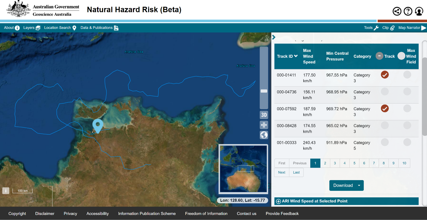
Selecting a point close to Darwin, the Tropical Cyclone Scenario Selection Tool returns four potential Category 3 tropical cyclones within 40km of Darwin (shown in the table on the right-hand side). Using the tool, users can then visualise the tracks of selected events. Here, two of the potential events have been selected and displayed on the map.
Identifying exposure and vulnerability to predict impact
Knowing where a tropical cyclone scenario might make landfall is just the first step to truly understand its impact and take on-the-ground action.
“Scenarios tells us the wind speed of a tropical cyclone, but don’t tell us what and who is in its path, or what the consequences might be,” Ms Carson said.
“This is where Geoscience Australia continues to support the emergency services – our Australian Exposure Information Platform (AEIP) tool gives emergency managers the information they need to understand what and who is in the path of the tropical cyclone scenario.”
Ms Carson notes the natural next question is ‘What does that mean and what can I do to prepare my community?’.
“This is where our vulnerability models come in. These models have been developed for residential buildings over many years in collaboration with James Cook University and they define the level of damage for the intensity of the tropical cyclone wind – the higher the wind speed, the higher the level of damage.
“The level of damage will depend on the nature of the residential building though – those built prior to 1980 will typically not fare as well as those built more recently to higher building standards.
“Combining these national scale hazard, exposure and vulnerability data and information provides decision-ready information so that emergency managers can better prepare for the next tropical cyclone season.”
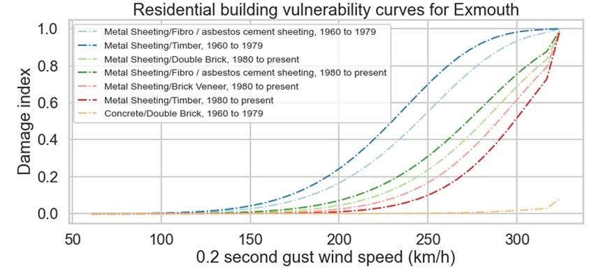
A set of wind vulnerability curves for different types of houses in Exmouth (WA). The different combinations of construction period, wall type and roof material will suffer different levels of damage when experiencing similar wind speeds.
Preparing communities
Geoscience Australia’s state partners in Western Australia and Queensland have been applying this knowledge as part of their own cyclone hazard and impact assessments.
In collaboration with the WA and QLD emergency services, Geoscience Australia developed hazard and impact assessments for a selection of scenarios for a subset of WA and QLD coastal locations. This information can inform disaster management and evacuation plans, as well as infrastructure planning and mitigation strategies.
“In 2018-2019 and 2019-20, this was used by WA DFES to support decisions made in the lead-up to TC Veronica and TC Damien,” Ms Carson said.
“Rather than wait, DFES was able to secure resources, such as emergency crews and equipment, and deploy them in advance to make the necessary preparations before the cyclones made landfall.
“With the 2020-21 tropical season about to start, the Queensland Fire and Emergency Services are also now better prepared than previous years thanks to this collaboration with Geoscience Australia.”
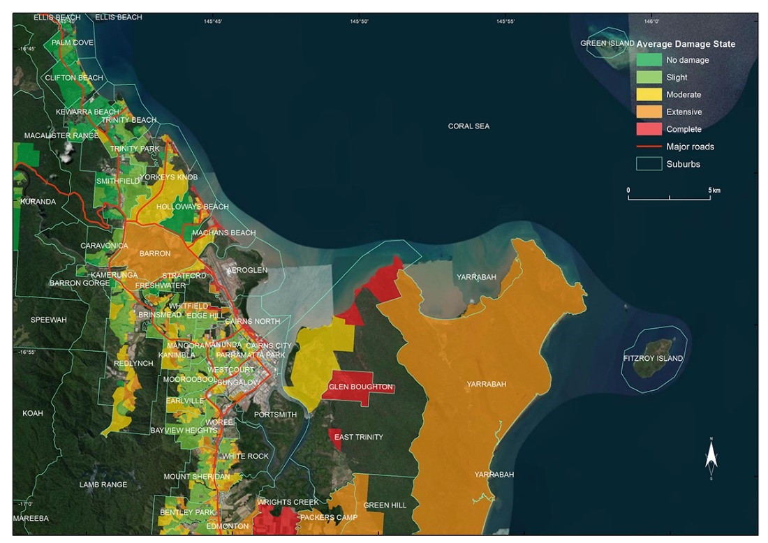
Estimated residential housing damage in Cairns from a potential category 5 tropical cyclone. The damage is estimated by combining the hazard (the wind field from the category 5 cyclone), exposure (the residential houses) and vulnerability (a model that estimates the damage level depending on the wind speed and the construction characteristics of the residential buildings).


