COVID-19 is having an enormous impact on the world. Its scale demands the support of many industries from health to emergency services to manufacturing. While the space industry can show us what’s happening beyond Earth, it is also helping on the ground. Here are some of the ways the industry is enabling us to visualise the impact and stay connected during this challenging time.
Satellite imagery
The impact of COVID-19 is visible from space. Satellite images are helping us understand the societal and economic changes that are taking place.
The mandate worldwide to #StayHome is evident through photos by space tech company, Maxar Technologies. Taken in March, the below images show some of Earth’s most crowded places now empty. This is evidence that people are staying home and practicing social distancing.
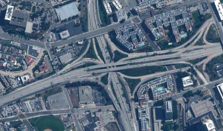
Busy Los Angeles highway with a notable decrease in traffic. Image credit: Maxar Technologies.
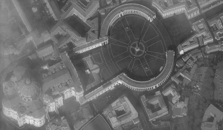
St Peter’s Square in Rome completely empty. Image credit: Maxar Technologies
These satellite images are also helping to identify and track construction of new medical facilities across the world in response to COVID-19. The images help us understand the size and pace of construction so we can manage medical needs in response to a rising number of COVID-19 cases.
Air pollution monitoring via Earth observation
Data from the European Space Agency’s (ESA) Earth observing satellite, Sentinel-5P, shows that air pollution has rapidly dropped during this pandemic.
When COVID-19 cases peaked in China, there was little nitrogen dioxide above Wuhan. Sentinel-5P’s powerful remote sensing function couldn’t detect significant levels to warrant registering. This went on for over two months! Europe, in particular Italy, and South Korea showed similar results: large drops in air pollution due to social distancing, remote working, reduced traffic and factories finding new ways to operate. The satellite results also showed improved air quality over Los Angeles, New York and Seattle.
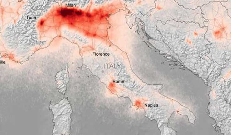
Nitrogen dioxide level in Italy during March 2020. Image credit: European Space Agency.
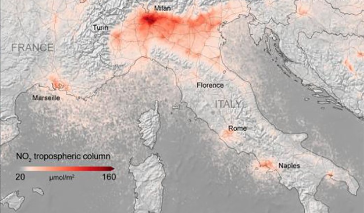
Compare the level after government placed country in lockdown, 14-25 March. Image credit: European Space Agency.
We shouldn’t ignore this data. Comparing air quality before and after the outbreak can help us discover a more environmentally friendly future with cleaner air.
Satellite-based position and navigation technology
Global Navigation Systems like the Global Positioning System (GPS), relies on Earth-orbiting satellites to provide geolocation and time information to GPS receivers anywhere on Earth.
These navigation systems are fundamental during a pandemic like COVID-19. They help with critical transportation and delivery of medical supplies and essential goods across the world. Emergency responders can also get to locations faster and more effectively. In some cases, global navigation systems can help provide real-time communication with drivers transporting critical goods. They can navigate rapidly changing traffic conditions when lock downs and traffic restrictions are in place.
Keeping connected with family, friends and work
There are many people who use satellite internet to connect with the world. Satellite communications help us maintain connection with our family and friends via popular video conferencing apps, especially when physical restrictions are in place.


