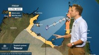
Senior Meteorologist, Dr Adam Morgan: Hello again. As tropical cyclone Trevor moves off the coast of western Cape York and into the Gulf of Carpentaria, the time to act is now for communities in the southwest Gulf ahead of its second coastal crossing towards the weekend.
Currently a Category 1 system just to the southwest of Weipa, tropical cyclone Trevor will intensify rapidly today.
With Trevor only just offshore, and gales still impacting the Queensland coast, a cyclone Warning remains in place for communities between Cape York and Pormpuraaw.
The Watch area extends further south to Kowanyama, and then right along the western and southern Gulf coasts from Nhulunbuy in the Northern Territory around to Burketown in Queensland.
The warm waters of the Gulf, and favourable conditions in the atmosphere mean there isn’t a lot to stop cyclone Trevor from becoming a large, powerful and extremely dangerous cyclone.
We should see Trevor reach severe Category 3 already by this afternoon, and then reach Category 4 intensity from Friday.
Gales are expected on Groote Eylandt from Friday, and at the core of the cyclone we may see wind gusts as high as 250 km/h as it approaches the NT coast.
Landfall at this stage looks most likely along the Carpentaria or east Arnhem coastlines, with those very destructive winds, heavy rainfall and very dangerous storm tides.
Daily rain totals are likely to be in the range 200–300 mm near the core of the system, and around 100–200 mm a little further afield.
Trevor may maintain tropical cyclone intensity for at least 24 h as it moves inland, with those heavy rains and damaging winds continuing.
Whilst remaining a dangerous weather system even as a tropical low, at this stage there is the chance it may move into the Barkly district later in the weekend—a region that’s desperate for rain after its driest wet season on record so far.
Cyclone Trevor poses extreme danger for communities around the Gulf.
Finalise your preparations and have your cyclone kits ready. Know your plan to stay safe as the cyclone approaches and follow all advice from emergency services.
Stay in touch with us on our website, app and social media for all the latest cyclone forecasts and warnings.


